
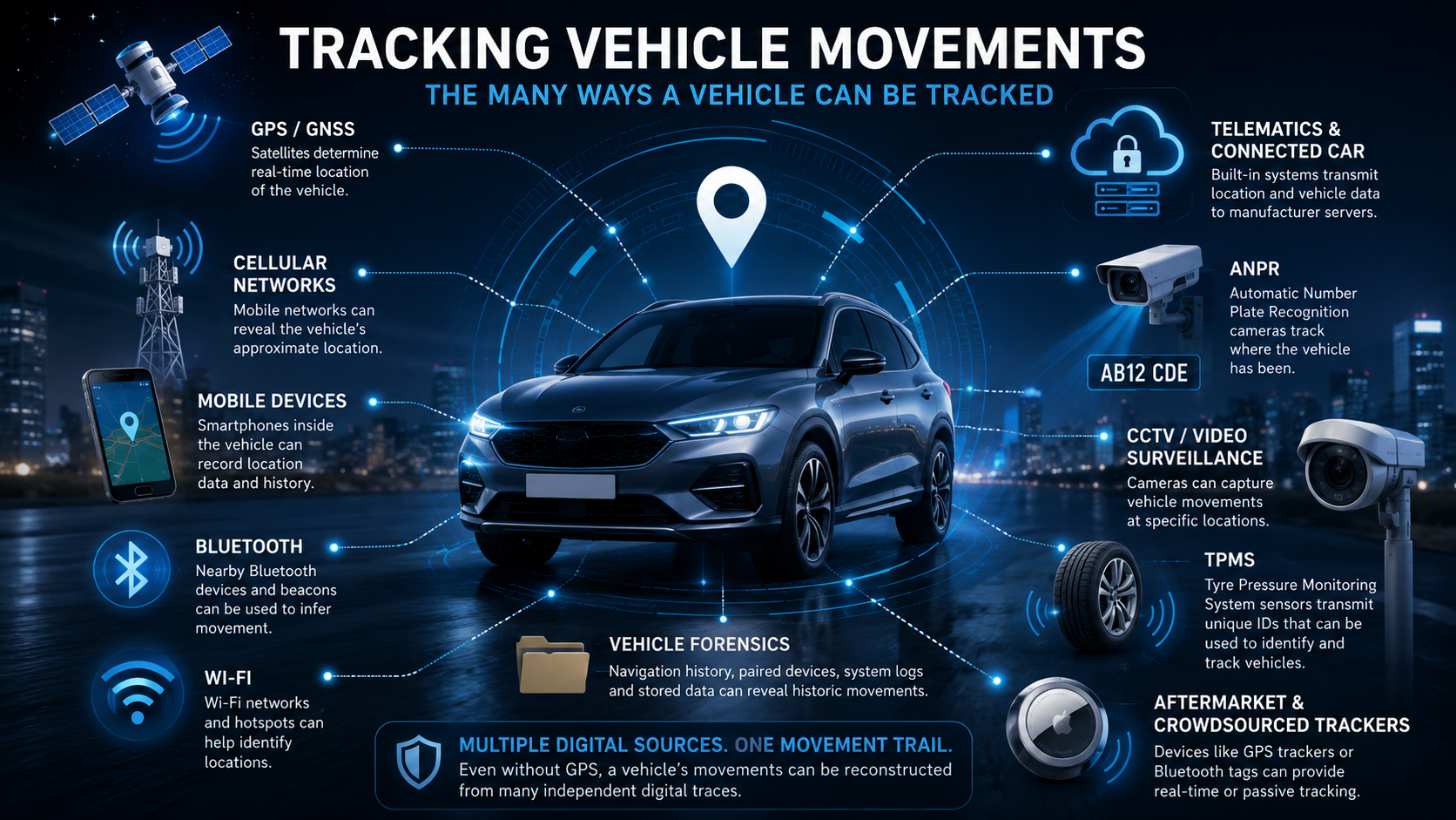
If you talk to most people about the ability to be tracked, the default tech that most people will mention is their mobile phone, and whilst this is very true – we are tracked to a very high degree by our mobile devices – most people would never consider the amount of tracking that occurs with a modern vehicle
In this post, I will take a look at the many ways modern vehicles can be tracked
Data inside the vehicle
1. GPS/GNSS tracking
A GPS tracker installed in, or attached to a vehicle determines its position using satellite navigation systems such as GPS, Galileo, GLONASS or BeiDou (depending on where in the world you happen to be). Once the location data is obtained by the satellite receiver, the data is normally transmitted esewhere using a cellular connection.
Trackers can be manufacturer-installed, fleet-management units, insurance telematics devices, OBD-II devices, or covert battery-powered/magnetically attached units
Key takeaway: GPS determines the location; another technology such as 4G/5G usually communicates it.
2. Built-in vehicle telematics
Many modern vehicles are effectively connected computers. Built into most modern vehicles are telematics control units (TCUs). These are built-in computer systems which collate and share all manner of vehicle data which is then used by other systems in the vehicle, but also is often sent via the internet to outside servers.
The TCU acts as the main hub for wireless communication, remote diagnostics, and safety tracking
Key Functions of a TCU
- Data Collection: Gathers statistics like speed, fuel use, engine codes, and braking habits from internal sensors
- GPS Tracking: Pinpoints the real-time physical location and movement of the vehicle
- External Connection: Uses cellular networks, Wi-Fi, or Bluetooth to send data to the cloud or fleet managers
- Emergency Support: Powers automated safety features like emergency crash notification systems
- Over-the-Air Updates: Allows car makers to send software updates directly to the vehicle without a dealer visit
The TCU may combine GNSS positioning with cellular connectivity and communicate with manufacturer cloud services.
Depending on the vehicle and service, this can support features such as vehicle location in a mobile app, stolen-vehicle recovery, emergency calling, remote diagnostics and journey history.
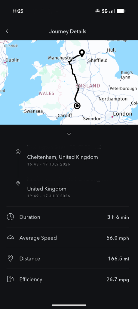
Consequently, historical or current location information may exist within the manufacturer’s telematics ecosystem rather than solely inside the vehicle.
Companies such as INRIX use crowd-sourced vehicle telemetry to obtain vehicle movements by collating data from these systems, but they also have partnered with many vehicle manufacturers to directly obtain this data from millions of vehicles worldwide.
Major Connected Car Brands include:
- Ford & Lincoln: All vehicles equipped with Ford SYNC, SYNC 3, and MyFord Touch.
- BMW & MINI: Passenger vehicles utilizing BMW ConnectedDrive Services, dating back to the BMW i3 and spreading across modern fleets.
- Volvo: Global vehicle lines including the V40, S60, V60, XC60, and the entire 90-series vehicle lineup via Volvo Sensus Connect.
- Toyota & Lexus: Selected regional models featuring factory-integrated navigation.
- Audi & Volkswagen: Selected models utilising localised traffic and parking intelligence features.
3. Mobile phones inside the vehicle
Sometimes the easiest way to track a vehicle is actually to locate its occupants.
A smartphone generates location data through GNSS, mobile cell networks, Wi-Fi positioning and other location-history services. A sequence of phone locations can therefore indirectly establish the movement of the vehicle carrying it.
From an investigation perspective, it is important to remember that the evidence establishes the phone’s location, not necessarily the vehicle’s location, but it is a useful indicator.
4. Cellular connectivity
A vehicles occupants may or may not be carrying a mobile phone. However, modern connected vehicles contain an embedded SIM/eSIM which communicates with mobile networks. Cellular network records can potentially establish the approximate area from which the vehicle’s telematics system communicated.
This is generally less precise than GNSS but may provide useful corroborating evidence.
5. Bluetooth and Wi-Fi
Vehicles continuously use short-range wireless technologies for functions such as phone pairing, infotainment, wireless CarPlay/Android Auto, hotspots and other connected services.
Wireless identifiers or characteristics observed by sensors at different locations can sometimes be correlated to infer movement.
Privacy protections such as Bluetooth Address Randomisation make simplistic identifier-based tracking much less reliable than it once was, but it should still be recognised as a source of data.
6. Dedicated radio tracking
Some stolen-vehicle recovery systems use dedicated radio transmitters rather than relying entirely on GNSS and cellular networks.
After a vehicle is reported stolen, compatible receivers can detect the transmitter and assist with locating the vehicle.
Such systems can sometimes continue functioning where satellite positioning or cellular connectivity is poor.
7. Aftermarket tracking devices
A separate tracker can be placed inside or attached to a vehicle. These include fleet trackers, OBD-II trackers, battery-powered GNSS trackers and asset-tracking devices.
Some vehicle trackers also contain accelerometers and can report movement, whether the vehicle is being towed or on a trailer or any impacts.
8. Bluetooth crowdsourced trackers
Devices such as Apple AirTags can provide indirect vehicle tracking. The tag does not work like a conventional GPS/cellular vehicle tracker, instead, the AirTags use a secure Bluetooth signal, using Apple’s Find My network, and utilising Ultra Wideband technology.

Nearby compatible devices detect the AIrTag and contribute observations to a crowdsourced finding network.
An Apple AirTag can be tracked globally anywhere in the world, utilising a direct Bluetooth range of about 30 to 100 feet and over an unlimited distance via the Apple Find My network
This is why these devices can potentially reveal the location of an object even though the tracker itself has no conventional mobile-data subscription
Other similar technologies work with Android devices. The best direct equivalents to Apple AirTags for Android are the Moto Tag, Samsung Galaxy SmartTag2, and Pebblebee Tag/Card.
Concerns over the inappropriate use of such tags gave rise to both Apple and Android intruducing technologies that cat detect unknown tags “travelling with you”.
Both iPhones and Android phones automatically detect unknown AirTags traveling with you by sending an alert, playing a sound, and allowing you to track or disable the rogue device.
How to check and respond on iPhone when you receive Alerts:
- Ensure tracking notifications are on under Settings > Notifications > Tracking Notifications.
- If an item moves with you, a “AirTag Found Moving With You” notification pops up on your device.
- To locate the Item: Tap the alert, press Continue, and select Play Sound or Find Nearby (utilizing Precision Finding on supported models).
- To review past alerts: Open the Apple Find My app, tap Items, and then select Items Detected With You.
- To identify and disable a device: Hold the top of your phone near the white side of the AirTag to see its serial number and owner info. Twist the back counter-clockwise and remove the battery to instantly stop sharing its location.
How to check and respond on Android with automatic & manual scans:
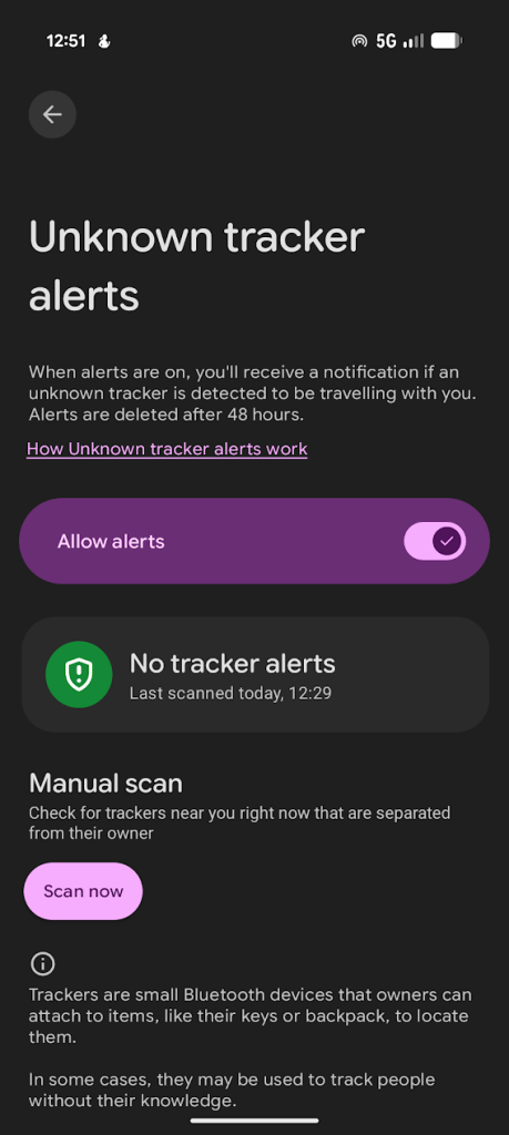
- Modern Android devices feature built-in detection under Settings > Safety & emergency > Unknown tracker alerts.
- You can also tap Scan Now or download the official Tracker Detect App from Google Play.
- Play a Sound: If an unknown tracker shows up, you can prompt it to emit an audible chime to help you find it.
- To disable the tracker: Just like with Apple Tags, opening the physical casing and taking out the battery halts all tracking permanently.
9. Vehicle-generated forensic evidence
The vehicle itself can also preserve evidence of where it has travelled, who was in the vehicle, and other data.
Depending on the model of the vehicle, forensic examination may recover navigation destinations, recent routes, GNSS coordinates, paired phones, Bluetooth connections, Wi-Fi networks, call records and timestamps. Modern vehicles will also record if a person was sat in a particular seat in the vehicle by storing information about the weight of the seat.
Infotainment and telematics systems can therefore be valuable sources of historical movement evidence.
10. Tyre Pressure Monitoring System (TPMS)
In many vehicles using direct TPMS, each wheel contains a battery-powered sensor that periodically transmits tyre information over a radio signal back to the CANBUs, and then on to the TCU of the vehicle.
Indirect TPMS does not use in-tyre monitors, instead it gauges differences in tyre pressure by monitoring the vehicles Anti-lock Braking System (ABS) wheel speed sensors to monitor how fast each tyre spins. If a tyre loses air, its rolling radius decreases, causing it to spin faster than the others, which triggers a dashboard warning – these systems do not use radio signals – they typically transmit data directly over the vehicle’s CANBus.
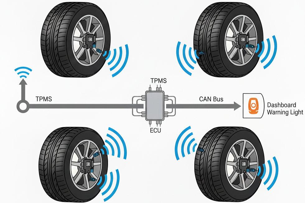
Each sensor has a unique ID, this ID is used to tell the vehicle which tyre is reporting the change in air pressure – this unique ID is also what can be tracked by roadside receivers.
Depending on the market and implementation, TPMS commonly operates around 315 MHz or 433 MHz.
The security/privacy issue is that some systems transmit identifiers wirelessly in a way that can provide a relatively persistent radio fingerprint. A roadside receiver could potentially observe:
Sensor IDs A/B/C/D → vehicle passes Sensor 1
Later that day:
Same IDs A/B/C/D → vehicle passes Sensor 2
The observer could therefore infer that the same vehicle passed both locations, without needing its registration plate information.
Data obtained from all four wheel sensors observed together can provide a stronger fingerprint than a single radio identifier:
Vehicle fingerprint = ID1 + ID2 + ID3 + ID4
So, even if another vehicle happened to share one of those characteristics, observing the same group repeatedly can strengthen the association.
Data outside the vehicle
1. Automatic Numberplate Recognition (ANPR)
ANPR does not continuously track the vehicle itself. Cameras situated in strategic locations identify the registration plate at particular location and time. This can then be analysed by the ANPR operator
In the UK, ANPR is extensively used by policing but can also be found in car parks, toll systems, petrol stations, airports and private parking infrastructures.
The principle of ANPR is as follows:
- Camera Capture and Image Processing
High-resolution photo: Specialised cameras take a clear photo of the front or rear number plate as a vehicle passes.
Infrared light: Infrared techbology helps the camera get a sharp picture whether the image was taken in the day or night, in rain or sunny conditions.
Cleaning the photo: The system adjusts brightness, changes the picture to grayscale, and removes blur or rain noise to make the numberplate characters easy to read. - Reading the Plate (OCR)
Finding the plate: Smart software uses computer vision to find exactly where the number plate is in the photo.
Turning picture to text: Optical Character Recognition (OCR) changes the shape of the letters and numbers into digital text data.
Database Check and matching: The digital text is checked in real-time against a computer list.
Common uses of ANPR include:
- Police check for stolen cars, lack of insurance, or wanted suspects
- Car parking: Systems log entry and exit times to calculate out how long a car stayed.
- Toll roads or congestion zones log the plate to identify the type of vehicle and charge an appropriate fee
2. CCTV and video analytics
Even without readable number plates, CCTV may establish where a vehicle was at a particular time.
Investigators can correlate vehicle characteristics such as make, model, colour, body shape, damage, stickers or other distinguishing features.
Advanced AI systems can automatically classify and search for vehicles matching particular characteristics, even if the image is blurred
Final thoughts
A vehicle does not need to transmit its GPS location to be trackable, or have its registration plate captured on a camera. Persistent wireless characteristics of the vehicle and its occupants can allow observations at different known locations to be correlated, creating a movement history that can be impossible to disprove.